Rongai Route
Want to Customize this Trip
Destination to Visit
Simba Camp, Second, Cave Camp, Kikelewa Camp, Mawenzi Tarn, Kibo Hut, Horombo Hut and Marangu Gate
Start / Finish in
Start in Moshi & End in Moshi
Request this Tour
Overview
The Rongai Route is one of the quieter and more gradual approaches to the summit of Mount Kilimanjaro. Beginning on the remote northern slopes near the Kenyan border, this trail is less crowded than many other Kilimanjaro routes, offering a peaceful trekking experience and expansive views across the plains of Kenya.
Because of its steady gradient and well-spaced camps, the Rongai Route is often considered one of the more accessible paths to the summit. The route provides good acclimatization over seven days and a high success rate for reaching Uhuru Peak, the highest point in Africa.
Trekkers begin the climb near Nale Moru and gradually ascend through pine forests, open moorland, alpine desert, and the dramatic high-altitude landscapes of Kilimanjaro. Along the way, hikers enjoy impressive views of Mawenzi Peak, the mountain’s rugged volcanic cone. The descent follows the southern side of the mountain via the Marangu Route, allowing climbers to experience two different sides of Kilimanjaro in one journey.
Day By Day
Day 1: Moshi to Umbwe Cave Camp
Your adventure begins with a morning drive from Moshi toward the northern side of Kilimanjaro. The journey takes approximately two to three hours and passes through small villages, farmland, and coffee plantations before reaching the trailhead near Nale Moru. After completing registration procedures and meeting your mountain crew, the trek begins.
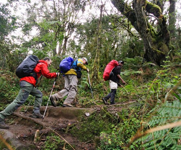
The trail starts on a broad path through open farmland where maize and potatoes are grown. Gradually the route enters a beautiful pine forest where wildlife such as colobus monkeys and various bird species can sometimes be seen.
The climb is gentle and steady, allowing your body to begin adapting to the altitude. By late afternoon you reach Simba Camp, located at the edge of the moorland zone, where wide views stretch across the plains toward Kenya.
- Elevation: 2000m to 2650m
- Distance: 6 km
Hiking Time: 3–4 hours - Habitat: Montane Forest
- Meals: Lunch & Dinner
Day 2: Simba Camp to Second Cave Camp
After breakfast, the trail gradually climbs through open moorland landscapes. The forest begins to disappear and the environment becomes more rugged, with low vegetation and scattered shrubs typical of high-altitude terrain.
As you gain elevation, the first clear views of Kibo, Kilimanjaro’s highest volcanic cone, appear ahead. The route remains relatively gentle, making it an enjoyable day of trekking while your body continues adjusting to the altitude.
The day ends at Second Cave Camp, a scenic campsite with impressive views of the mountain and surrounding plains.
- Elevation: 2650m to 3450m
- Distance: 6 km
- Hiking Time: 3–4 hours
- Habitat: Moorland
- Meals: Breakfast, Lunch & Dinner
Day 3: Second Cave to Kikelewa Camp
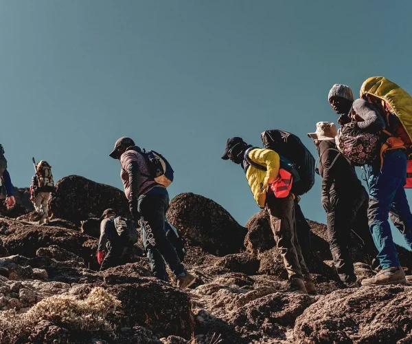
Today the trail leaves the main route and follows a smaller path heading toward the dramatic peaks of Mawenzi. The terrain becomes more open and rocky, with spectacular views across the northern side of the mountain.
As you continue trekking through the moorland landscape, unique alpine plants such as giant senecios begin to appear. These unusual plants thrive in the high-altitude environment and add character to the scenery.
The day ends at Kikelewa Camp, located in a sheltered valley surrounded by rugged mountain slopes. The campsite provides a quiet and scenic place to rest while preparing for higher elevations.
- Elevation: 3450m to 3600m
- Distance: 9 km
- Hiking Time: 4–5 hours
- Habitat: Semi-desert
- Meals: Breakfast, Lunch & Dinner
Day 4: Kikelewa Camp to Mawenzi Tarn
This morning begins with a short but steep climb up grassy slopes toward the impressive spires of Mawenzi. As you gain altitude, the vegetation gradually fades, replaced by rocky alpine terrain.
The trail leads to Mawenzi Tarn, a beautiful campsite located beneath the towering cliffs of Mawenzi Peak. The camp sits beside a small glacial lake surrounded by dramatic volcanic formations.
The afternoon is intentionally kept free for rest or short acclimatization walks in the surrounding area. Spending time here helps your body adjust to the altitude before moving higher on the mountain.
- Elevation: 3600m to 4330m
- Distance: 6 km
- Hiking Time: 3–4 hours
- Habitat: Semi-desert
- Meals: Breakfast, Lunch & Dinner
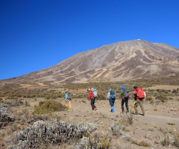
Day 5: Mawenzi Tarn to Kibo Hut
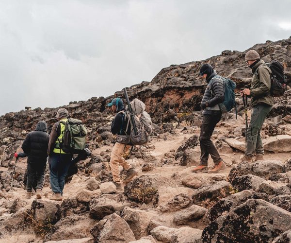
After breakfast, the trek crosses the wide alpine desert known as the “Saddle,” the vast plateau that lies between the peaks of Mawenzi and Kibo. This area is dry, windy, and starkly beautiful, resembling a lunar landscape.
The trail gradually climbs across this open terrain until reaching Kibo Hut, situated at the base of Kibo’s crater wall. This camp serves as the starting point for the summit attempt.
The afternoon is spent resting, organizing equipment, and preparing mentally and physically for the midnight ascent to the summit.
- Elevation: 4330m to 4750m
- Distance: 9 km
- Hiking Time: 4–5 hours
- Habitat: Alpine Desert
- Meals: Breakfast, Lunch & Dinner
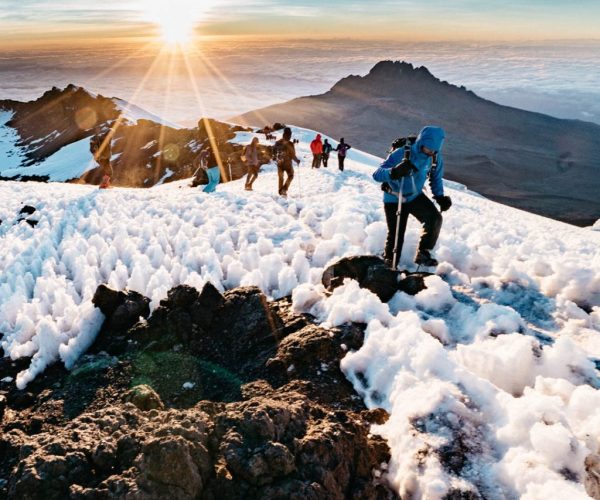
Day 6: Kibo Hut to Summit to Horombo Hut
Around midnight, climbers begin the final ascent toward the summit. Equipped with headlamps, the group slowly climbs steep scree slopes in the darkness, moving steadily toward Gilman’s Point on the crater rim.
After reaching Gilman’s Point, the trail continues along the rim toward Uhuru Peak, the highest point in Africa. Reaching the summit at sunrise offers unforgettable views across glaciers and the vast landscapes below.
After celebrating at the summit and taking photos, climbers begin the long descent back to Kibo Hut for a short rest and lunch. The trek then continues downward to Horombo Hut, where trekkers enjoy a well-earned rest after the most demanding day of the climb.
- Elevation: 4700m to 5895m then down to 3700m
- Distance: 6 km ascent / 15 km descent
- Hiking Time: 11–14 hours total
- Habitat: Alpine Desert and high-altitude summit
- Meals: Breakfast, Lunch & Dinner
Day 7: Horombo Hut to Marangu Gate
The final day begins with a relaxed descent through moorland and eventually back into the lush rainforest zone. The trail passes Mandara Hut before continuing down through dense vegetation filled with birds and forest wildlife.
Upon reaching Marangu Gate, climbers complete park formalities and receive their summit certificates. A vehicle then transfers you back to your hotel in Moshi for a well-deserved rest and celebration.
- Elevation: 3700m to 1700m
- Distance: 20 km
- Hiking Time: 5–6 hours
- Habitat: Forest
- Meals: Breakfast
LOOKING FOR A KILIMANJARO TREKKING DATES?
Contact us. Our team is always here to help.
RECOMMENDED FOR
Adventure seekers who dream of reaching the summit of Mount Kilimanjaro, the highest peak in Africa.
Nature lovers who want to experience diverse landscapes, from rainforest and moorland to alpine desert and glaciers.
Travelers seeking a personal challenge and a rewarding sense of achievement at the summit.
PRICE INCLUSION
- All Game Drives;
- Accommodation At Lodges/Tented Camps
- English Speaking Driver/Guide;
- All Food; Drinking Water;
- 18% VAT Tax;
- At Least 1 Pair Of Binoculars;
- Accommodation In Moshi/Arusha;
- Airport Transfers;
PRICE EXCLUSIONS
- International flights
- Tanzania visa fees
- Travel insurance
- Tips and gratuities (guide, driver, lodge staff)
- Personal expenses (laundry, phone calls, souvenirs)
- Alcoholic and soft drinks (unless stated)
- Optional activities