Machame Route
Want to Customize this Trip
Destination to Visit
Machame Camp, Shira Camp, Barranco Camp , Karanga Camp, Barafu Camp, Uhuru Peak and Mweka Camp
Start / Finish in
Start in Moshi & End in Moshi
Request this Tour
Overview
The Machame Route is one of the most scenic and popular trails used to climb Mount Kilimanjaro, the highest mountain in Africa. Often called the “Whiskey Route,” it is considered more challenging than the Marangu Route due to its steeper trails and longer trekking days. However, it is also regarded as one of the best routes for acclimatization, offering climbers a better chance of successfully reaching the summit.
This route approaches the mountain from the southwest and descends through the Mweka trail. Trekkers experience an incredible variety of landscapes as they pass through five distinct ecological zones, including rainforest, moorland, alpine desert, and the arctic summit region. Along the way, climbers enjoy breathtaking views of the expansive Shira Plateau, dramatic volcanic formations like Lava Tower, and the famous Barranco Wall.

Day By Day
Day 1: Moshi to Umbwe Cave Camp
After breakfast at your hotel, you will drive from Moshi to Machame Gate, located within Kilimanjaro National Park. The journey takes about 45 minutes and passes through local villages on the lower slopes of the mountain.
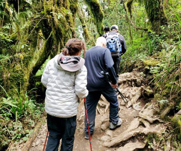
Upon arrival, climbers complete registration formalities before beginning the trek. The trail starts in dense rainforest, where towering trees and thick vegetation create a cool and shaded environment. The path gradually climbs along a ridge and can sometimes be muddy or slippery, especially after rain.
As you continue higher, you may spot wildlife such as colobus monkeys and various bird species. After several hours of hiking, you reach Machame Camp, located just above the forest zone, where you will spend the night.
- Elevation: 1830m / 6000ft to 3050m / 9950ft
- Distance: 11 km / 7 miles
- Hiking Time: 5–6 hours
- Habitat: Montane Forest
- Meals: Lunch and Dinner
Day 2: Machame Camp to Shira Camp
Today’s trek begins with a steady climb out of the rainforest into the open moorland zone. As the vegetation becomes less dense, the landscape opens up to reveal wide views of the surrounding valleys and mountain ridges.
The trail follows a rocky ridge before crossing a valley and continuing toward the vast Shira Plateau. Along the way, trekkers can see unique high-altitude plants such as giant heathers and other hardy alpine vegetation.
By afternoon, you arrive at Shira Camp, situated on the beautiful Shira Plateau, one of Kilimanjaro’s oldest volcanic formations. The area provides excellent views of the summit and surrounding landscapes.
- Elevation: 3050m / 9950ft to 3850m / 12,600ft
- Distance: 5 km / 3 miles
- Hiking Time: 4–5 hours
- Habitat: Moorland
- Meals: Breakfast, Lunch and Dinner
Day 3: Shira Camp to Lava Tower to Barranco Camp
This day is crucial for proper acclimatization. The trek begins with a gradual ascent across the Shira Plateau before climbing toward Lava Tower, a dramatic volcanic rock formation also known as the “Shark’s Tooth.”
The trail reaches its highest point of the day at Lava Tower, giving trekkers the opportunity to experience higher altitude before descending again. This “climb high, sleep low” strategy helps the body adapt more effectively to the altitude.
After lunch near Lava Tower, the route descends into the scenic Barranco Valley, surrounded by giant groundsels and towering cliffs. You will spend the night at Barranco Camp, one of the most beautiful camps on the mountain.
- Elevation: 3850m / 12,600ft to 4000m / 13,000ft
- Distance: 10 km / 6 miles
- Hiking Time: 5–6 hours
- Habitat: Semi-desert
Meals: Breakfast, Lunch and Dinner
Day 4: Barranco Camp to Karanga Camp
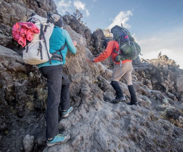
The day begins with the climb up the famous Barranco Wall, a steep but manageable rock face that offers an exciting scramble and spectacular views of the surrounding valleys.
After reaching the top of the wall, the trail descends slightly before crossing alpine ridges and valleys toward the Karanga Valley. This section of the trek offers stunning views of glaciers and the southern slopes of Kilimanjaro.
You arrive at Karanga Camp in the afternoon, where climbers rest and prepare for the final approach to the summit.
- Elevation: 4000m / 13,000ft to 4050m / 13,250ft
- Distance: 5 km / 3 miles
- Hiking Time: 3–4 hours
- Habitat: Alpine Desert
- Meals: Breakfast, Lunch and Dinner
Day 5: Karanga Camp to Barafu Camp
After breakfast, the trail continues steadily upward toward Barafu Camp, the final base camp before the summit attempt. The route passes through barren alpine desert terrain with expansive views of the summit ahead.
By this stage of the trek, climbers have completed the famous Southern Circuit of Kilimanjaro, which provides panoramic views of the mountain from several angles.
Upon arrival at Barafu Camp, trekkers rest, eat an early dinner, and prepare for the overnight summit climb. Guides provide a detailed briefing before climbers head to sleep early.
- Elevation: 4050m / 13,250ft to 4700m / 15,350ft
- Distance: 4 km / 2 miles
- Hiking Time: 3–4 hours
- Habitat: Alpine Desert
- Meals: Breakfast, Lunch and Dinner
Day 6: Barafu Camp to Uhuru Peak to Mweka Camp
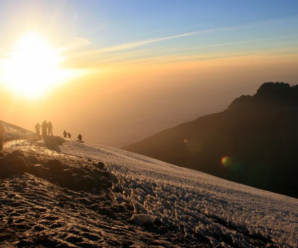
The summit attempt begins around midnight. Climbers leave Barafu Camp and begin a slow ascent toward the crater rim, trekking across steep slopes of volcanic scree.
After several hours of climbing, you reach Stella Point, where the sunrise often illuminates the glaciers and surrounding landscapes.
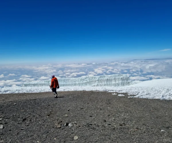
From Stella Point, the trail continues along the crater rim for the final stretch to Uhuru Peak, the highest point on Kilimanjaro and in all of Africa. After celebrating your achievement and taking photos at the summit, the descent begins.
You return to Barafu Camp for a short rest and meal before continuing down to Mweka Camp, located in the forest zone.
- Elevation: 4700m / 15,350ft to 5895m / 19,340ft
- Descent to: 3090m / 10,150ft
- Distance: 5 km up / 13 km down
- Hiking Time: 5–7 hours up / 5–6 hours down
- Habitat: Arctic Summit / Alpine Desert / Forest
- Meals: Breakfast, Lunch and Dinner
Day 7: Mweka Camp to Mweka Gate
On the final day, the trail descends through lush rainforest toward Mweka Gate. The path can be muddy in some areas, especially after rain, so trekking poles can be useful during the descent.
Upon reaching the gate, climbers receive their official summit certificates before returning by vehicle to their hotel in Moshi for a well-earned rest.
- Elevation: 3090m / 10,150ft to 1680m / 5500ft
- Distance: 10 km / 6 miles
- Hiking Time: 3–4 hours
- Habitat: Forest
- Meals: Breakfast
LOOKING FOR A KILIMANJARO TREKKING DATES?
Contact us. Our team is always here to help.
RECOMMENDED FOR
Adventure seekers who dream of reaching the summit of Mount Kilimanjaro, the highest peak in Africa.
Nature lovers who want to experience diverse landscapes, from rainforest and moorland to alpine desert and glaciers.
Travelers seeking a personal challenge and a rewarding sense of achievement at the summit.
PRICE INCLUSION
- All Game Drives;
- Accommodation At Lodges/Tented Camps
- English Speaking Driver/Guide;
- All Food; Drinking Water;
- 18% VAT Tax;
- At Least 1 Pair Of Binoculars;
- Accommodation In Moshi/Arusha;
- Airport Transfers;
PRICE EXCLUSIONS
- International flights
- Tanzania visa fees
- Travel insurance
- Tips and gratuities (guide, driver, lodge staff)
- Personal expenses (laundry, phone calls, souvenirs)
- Alcoholic and soft drinks (unless stated)
- Optional activities